Altenahr is a picturesque village known for its stunning nature, hiking trails, and vineyards. The region attracts many tourists, thanks in part to the nearby Ahr River and various historical landmarks.
Since I live very close to Germany, I often venture across the border to explore the natural beauty of our neighbors. This time, my search led me to the charming Altenahr, a place I discovered through Facebook hiking groups. The landscape and history of this region immediately appealed to me, and I couldn’t wait to explore it for myself.
I couldn’t find a marked route online, so I turned to the Komoot app. A route full of challenging scrambles caught my eye, but I soon realized it was a bit too ambitious. Eventually, I found a 13-kilometer hike with 450 meters of elevation—just what I was looking for! With the sunny weather forecast and a four-hour round trip by car, this seemed like the ideal distance for a day hike.
When I arrived, the sun was shining brightly, which always makes for more vibrant photos. However, as I parked the car, I was immediately confronted with the lasting scars from the summer floods of 2021, something I had previously noticed during hikes in the Eifel. Nature was still bearing the brunt of it, but fortunately, the landscape offered scenes of hope and renewal. From the parking lot, I had a view of a tranquil river and a beautiful bridge, and shortly after, I spotted a sign pointing me towards the Teufelsloch (Devil’s Hole). The trail quickly began to climb steeply towards the Black Cross, a historic point from 1865, which was placed as a marker opposite the White Cross.
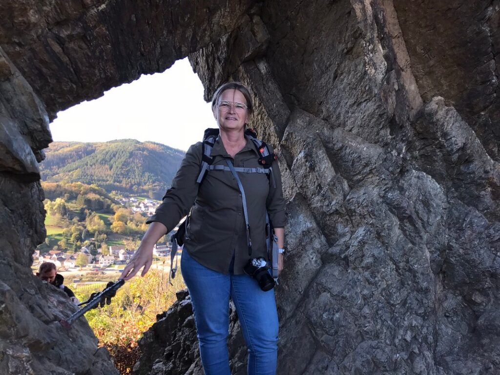
The path to the Devil’s Hole (or Teufelsloch) was no easy climb. In some sections, steel cables had been installed to assist hikers, which were certainly not a luxury. It was a popular spot, and after a short wait, I was able to snap a picture of the unique rock formation. In the first few kilometers, I was already treated to breathtaking views and interesting landmarks.
The Teufelsloch is a hole in the volcanic rock offering a charming view of the surrounding area.

After leaving the busy Teufelsloch behind, I continued walking peacefully, enjoying the autumn colors that dominated the landscape. At the top of a hill, I found a bench overlooking the vineyards, where the vines had turned a variety of warm shades. It was the kind of place where you could sit for hours, simply soaking in the view. If I were a painter, I would have started a masterpiece right there!
As I was lost in thought, imagining a painting, a mountain biker stopped by to admire the scenery as well. What started as a brief exchange of glances turned into a surprisingly pleasant conversation. My German is far from perfect, but I always try my best to make myself understood. He told me about the devastating floods in the summer of 2021, where large parts of the landscape were submerged. His enthusiasm for the region was infectious, and he gave me a new perspective on grape cultivation and how the seasons have affected the vineyards.
After our chat on the bench, I continued my journey and soon reached a wooden lookout point with an even more spectacular view. I took my time admiring the colors before moving on to the viewpoint that revealed the ruins of Burg Are.
The Ruins of Burg Are
This castle was built around 1100 by Count Dietrich I of Are. However, since 1714, it has been in ruins after being blown up. Between 1997 and 1999, it was restored, an operation that must have been spectacular as they used helicopters for the work. After the restoration, it was declared a protected monument.
According to Komoot, the path should have led downhill from here, but unfortunately, that was not the case. The path Komoot indicated no longer existed. Instead of turning back, I decided to take an alternative route through the forest. This turned out to be a mistake.
After a steep descent, I found myself stuck, unable to move forward or retrace my steps. The only option was to climb back up. The terrain was wild and rugged, and even with my trekking poles, the ascent was tough. After a grueling 300-meter climb, I thankfully rejoined the regular path.
The last kilometers of the hike took me along the Ahr River, which I crossed several times over temporary bridges. The sound of the rushing water and the jagged rock formations along the river made these final stretches of the hike even more impressive. When I finally reached the Black Cross again, I knew I was close to the car. In the end, the hike was 2 kilometers longer and 300 meters steeper than I had planned, but it was well worth the effort.
Our Photos
We take photos with our phone, mirrorless camera, or compact camera. We don’t edit our experience photos with colors or filters; all the colors you see are exactly as we observed them.
A Walking Pin
Would you like a walking pin as a souvenir of this hiking route? You can click here.
Other Hikes
If you’d like to read more about our hikes, check out our overview page.
Subscribe to our newsletters and miss no promotions, new collections or blogs!